
7:50PM Sunday update... Here's the newest information this Sunday evening.
When making a snow forecast, I was taught to always think about what could go wrong with it. I keep thinking about the previous 2 disturbances: Thursday and Saturday afternoon. On Thursday morning, we thought there could be a few flurries. Instead, that turned out to be a dusting to 4 tenths of an inch. Not much at all, but more than we expected and it caused a few slick spots. The system Saturday was forecast to produce a couple snow showers or a little sleet. I don't think anyone saw the possibility for "thundersleet" across northern Arkansas. So that's in the back of my mind when making a forecast for late Sunday into Monday morning.
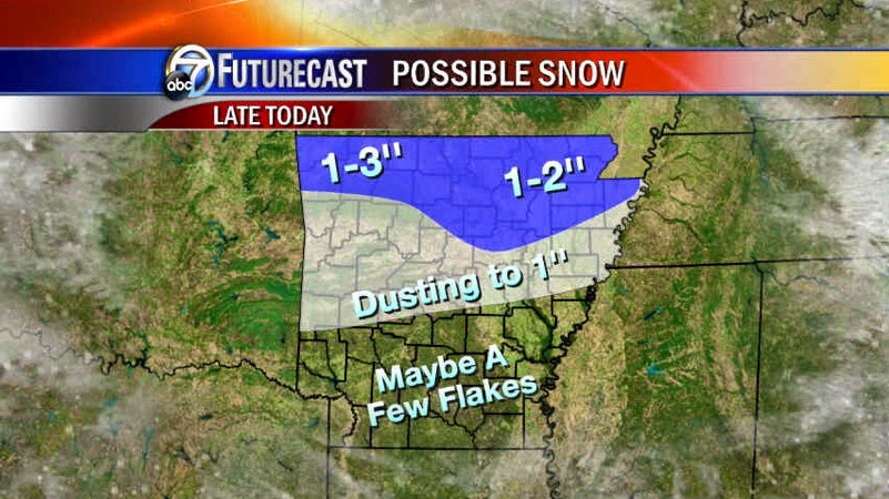
I can't emphasize this enough... I would NOT call this a "snow storm". This will be the type of snow, especially for northern Arkansas, which will cause a few travel problems and I expect school closings. Further south into the metro, I have taken snowfall accumulations further south. At this time, I think a dusting to an inch is a good forecast for the metro. Many times, people will only see the "1 inch" in the forecast and if they only get a dusting they think the forecast is wrong. A "sleddable snow"? Yes, for SOME! Obviously up north!
The coldest air of the season will push into the state Monday with strong northerly winds 15-25 mph with higher gusts. This will produce wind chill values in the teens and 20s. Tuesday morning will bring lows in the teens and low 20s. I also expect a warm up to begin by mid week, but temperatures may stay a little below average.
Below are maps from our exclusive model "FUTURECAST". It's important to remember, no snow forecast will be absolutely perfect. This is our current thinking.
 |
| By noon, we could see a round of light snow across NW Arkansas. This MIGHT be a little early, but worth watching. |
 |
| By 4PM, that lifts north and we'll watch more snow expand out of Oklahoma. |
 |
| By 9PM, a mix can be expected across the metro with light snow north of Little Rock. |
 |
| By midnight, the northern half of the state is seeing some snow. It may even extend as far south as Hot Spring and Jefferson county. |
 |
| By 2AM, it quickly moves out of the Channel 7 viewing area. |
 |
| It's important to remember, NO snow forecast will be perfect, but this is a good preliminary look. This can still change pending more data. It's possible some of the higher elevations could reach 3'' in the Ozarks |
 |
| The GFS shows something similar with the target area over northern Arkansas. |
 |
| The hi res GFS. ONLY A MODEL |
 |
| And the Euro. |


1 comment:
Thanks, Todd. The AWB is a valuable tool for me as a teacher.
Post a Comment