It's in the cards for Saturday morning!!! A quick moving disturbance with cold air in place will create areas of light snow and sleet central and northern Arkansas. Of course, there could also be some rainfall with this mixed in. It should be mostly light rain south.
Winds will howl tonight as the cold air pours into the state. Below, I have the timing of the precip, but first, here's an interesting fact. There has never been more than a trace of snow in Little Rock during the month of April. Records date back to the 1870s. The National Weather Service counts sleet as snow, so remember that Saturday. If there's any accumulations, IF, it would be light and mainly on grassy surfaces across northern Arkansas
Also, record lows each morning this weekend is 28°. I don't think it's possible to reach it, but it's Arkansas. Things like that happen.
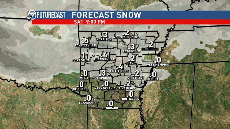
Below is the 3KM NAM from WeatherBell.com PLUS model accumulation maps. DO NOT take the accumulations literally. Just look at the area the models paint with accumulation and those are the areas most likely to see a wintry mix. FULL disclosure, this model is the most aggressive with wintry weather. Other models not so much, but they still have it.
FYI, I don't like what I see on the models for late next week. Very warm air may surge north with a strong front approaching. We'll have to watch for the threat for severe weather at that time. Let's get through this weekend first. :)
 |
| 7AM Saturday. Peach is sleet, blue is snow, and green light rain. Other models have this moving in faster. |
 |
| 9AM Saturday |
 |
| 10AM |
 |
| 11AM |
 |
| Noon |
 |
| By 1PM, it's all east and we're clearing out. The spring game at War Memorial will be mostly dry, windy and cold. |
AGAIN, DON'T TAKE THESE MAPS LITERALLY!!! They all agree where the best chance for seeing a wintry mix is located.


No comments:
Post a Comment