Thursday, June 28, 2012

METAR 101 and Why We're Having Record Heat

FOLLOW ON FACEBOOK: TODD YAKOUBIAN
TWITTER: KATV_WEATHER

There was some confusion today when it comes to the temperature at Little Rock.  Was it 107 or 108 degrees for the high temperature?  John Robinson with the National Weather Service office in North Little Rock explains in this email he sent me.

"Automated observations taken by ASOS (Automated Service Observing System) at airports such as Little Rock contain a coded group near the end, called a T Group.

The T Group begins with the letter T and contains 8 digits, which represent the current temperature and dewpoint with an accuracy to one-tenth of a degree Celsius.  For example, consider the following observation from Little Rock:
KLIT 282053Z 25009KT 10SM CLR 42/12 A2997 RMK AO2 SLP146 T04170122 58017
The T Group, T04170122, means that the current temperature is +41.7C and the current dewpoint is +12.2C.

The temperature conversion used by ASOS then takes the 41.7C temperature and converts this to 107F.  This is done this way not only by ASOS but also by the program that produces the NWS' Hourly Weather Roundup, which is seen on the Internet each hour.  Apparently, some programs outside the NWS do not use the T group in converting temperatures from C to F.  Instead, they use the 2-digit temperature group, in whole degrees C, seen in the main part of the observation.  This would be "42" in the observation above.  Using the 2-digit group with whole degrees is not as exact as using the 3-digit group with degrees and tenths.

So, again, the 41.7C is converted to Fahrenheit and becomes 107F.  If the 42 in the main part of the observation is converted instead, the 42C would equate to 108F, but that's not the point at which the conversion is supposed to be done.  If you do the raw conversion of C to F, 41.7C comes out to 107.1F, so it's not even getting close to 108F.  Of course, just because it was 41.7C on the hourly observation, that doesn't necessarily mean that it didn't get a tad higher between hours.  If, for example, it actually topped out at 41.9C, that would come out to 107.4F.

Every 6 hours, ASOS puts a 1 Group and a 2 Group at the end of the observation.  The 1 Group is the exact temperature in Celsius (degrees and tenths) that was the high for the 6-hour period that is ending, and the 2 Group shows the low.  So, let's consider this observation from Little Rock: 
KLIT 282353Z 18010KT 10SM CLR 39/14 A2994 RMK AO2 SLP138 T03890144 10417 20383 56008
The 1 Group here is 10417, which says the high for the day was 41.7C, which equates to 107.1F.

Before the NWS sends out the Climate Summary with the statistics for that day, the ASOS is called and it reports what the high and low, in Fahrenheit, have been so far that day.  At the end of the day, the high and low for the 24-hour period will go into the official record.

Some smaller airports have automated observing systems called AWOS (Automated Weather Observing System).  Typically, these observations do not contain T Groups, 1 Groups, and 2 Groups.  Thus, there is no choice but to use the 2-digit Celsius temperature in the main part of the observation as the current temperature, and convert it to Fahrenheit.  The high and low have to be determined by taking the highest and lowest temperatures appearing on any observation and using these as the high and low for the day, since there is no way to tell whether a high or low for the day might have occurred in-between transmitted observations."
_____________________________________________________________________

Anyone who said they forecast 107 degrees for the high temperature today isn't telling you the truth.  With that said, the forecast did call for 102-103 degrees today.  That's not too far off, but when you're talking about extremes, people notice the difference.

Anyway, what caused it?  It was the perfect combination of what I call the "Triple Ingredients To Top 100" plus one other very important factor which made it get out of hand.  I'll explain.  Normally in summer here are the 3 ingredients to hit 100....

1. Strong high pressure
2. Dry ground
3. Ample sunshine

We had all of that Thursday plus one other factor which caused temperatures to reach levels never seen before in June weather history for Little Rock and other locations.... DRY AIR!

The presence of dry air allows the temperature to cool rapidly and efficiently at night, but it heats rapidly during the day.  Usually during an Arkansas summer, we have thick and high humidity levels.  Water vapor is the number 1 greenhouse gas in our atmosphere.  High levels of humidity will prevent temperatures from varying too much compared to when dry air is in place.  Heat gets trapped by water vapor and it's not allowed to enter or escape as efficiently compared to the drier air.  I hope this makes sense.

However, when the humidity levels are high, it feels even hotter due to the inability for your body to cool itself.  Evaporating moisture off your body is more difficult because the air surrounding you is already full of moisture.  When dry air is in place, the evaporation rate is much higher and you will not sweat as much.  This can lead to evaporational cooling.  That's what we experienced Thursday.  Dewpoint values were in the 50s and with readings around 107, it felt like 105 degrees.  There was an actual cooling effect due to the dry air.

Now when dewpoints rise, the temperature may not reach the extreme levels it did Thursday, but since your body can't cool itself properly, the "feels like" temperature exceeds the actual temperature.

Over the next few days, the humidity levels will begin to increase some and this will take temperatures down very slowly, but it will feel hotter because of humidity levels will increase.  The National Weather Service has already issued a heat advisory for Friday and Saturday to account for this.

Someone asked why we didn't have thunderstorms develop.  The dry air didn't allow for that and there was a very strong cap in place meaning the air couldn't rise enough to build clouds or even storms.

As moisture levels do increase, the chance for isolated, stray showers may increase as well, but the coverage will be extremely small.  In other words, the drought continues for at least the next week and probably beyond.

Here are the daily record highs over the next 2 days.  They will be challenged.

Friday June 29th... 105 (1988)
Saturday June 30th... 102 (1931)

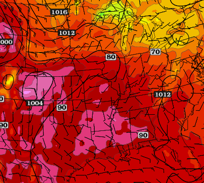
In the upper levels, strong high pressure is in control.  The jet stream and cooler air is locked up to the north.  This is very typical in the summer
The visible satellite shortly after 4 PM shows virtually NO cloud cover bringing us tons of sun.  Another ingredient for super hot weather.
The dry ground is also taking its toll.  The suns energy is used in heating the air since the soil moisture is almost gone.  The map above shows many areas now in an "extreme" drought.
This is from the National Weather Service office in NLR.  Check out the widespread misery.
Here's a preliminary list of highs today from the NWS office in North Little Rock.

Wednesday, June 27, 2012

PLEASE, NO MORE RECORDS!!!!!!!

FOLLOW ON FACEBOOK: TODD YAKOUBIAN
TWITTER: KATV_WEATHER

It's not even July and it's safe to say we're sick of the heat already.  After experiencing the hottest June day ever in recorded Little Rock weather history, we're looking for any relief we can find.  Looking at the long range models, I can't find any chance for significant rainfall.  The entire state has a "high" wildfire danger and with the 4th of July right around the corner, I expect some places to move into the "extreme" category.

While western Arkansas may have a few 100 degree temperatures Wednesday, widespread triple digit temperatures will return to the remainder of the state Thursday.  This means we will once again challenge daily record high temperatures at many locations including Little Rock.  Here are the records through June 30th

Thursday June 28th... 103 (1954)
Friday June 29th... 105 (1988)
Saturday June 30th... 102 (1931)

Little Rock has not had measureable rainfall since June 12th.  This means we'll have to keep an eye on yet another record.. longest consecutive days without rainfall.

As of Wednesday, it's 15 days.  Number 1 on the list is the period from July 27th, 1995 to September 3, 1995 (39 days)

The 10th longest period is June 29th, 1986 to July 30th, 1986 (32 days).

Some might say it's a little too premature to talk about this, but after reviewing the long range data, there is little hope for widespread rainfall over the next couple of weeks.  If that data is correct, this record could go down as well.

For those of you in the summer contest, the numbers are changing daily and I'll keep them updated.

Stay cool... heat is the number one weather related killer!  Please stay safe!!!!!!!!!

Sunday, June 24, 2012

Heat and Hurricanes

FOLLOW ON FACEBOOK: TODD YAKOUBIAN
TWITTER: KATV_WEATHER

4:45 PM Sunday update... It was a record breaking day with highs of 101 in both Little Rock and North Little Rock.  I think we'll do it all over again Monday with high temperatures right around 100 degrees.  A front will slide through the state bringing a very, very small chance for a shower or storm later Monday followed by a brief cool down.

As mentioned below, the forecast track of Debby was highly uncertain.  The European model has now shifted and is forecasting the storm to move more eastward.  Now, most models have the storm more on an eastward course and the Tropical Prediction Center has drastically changed their forecast.  They are favoring a Florida panhandle hit, but I think it may go a bit further to the east.  Regardless, this will have no impact on Arkansas weather, but will impact Arkansans vacationing on the beach down there.  This track may also help keep gas prices from rising too much, but I'm not an expert in that field.  I'll keep you updated here on the Arkansas Weather Blog.

____________________________________________________________________________

It comes down to this question:  Would you rather have drought conditions or extreme flooding?  The later option could also come with tornadoes and I'll explain in a bit.  First of all, it's a lose - lose situation all around for Arkansas.

A very powerful ridge of high pressure will bring near record breaking temperatures Sunday and Monday with several locations hitting 100 degrees or higher.  In Little Rock we'll top out around 97-100 degrees.  The record Sunday is 100 set in 1998 and the record Monday is 101 set in 1998.  The wildfire danger will be categorized as either high or even extreme.  The bottom line, we need rain!  However, rains from a slow moving tropical system can be devastating.

Tropical Storm Debby continues to spin in the Gulf and she is in no hurry to move.  The slower the system, the heavier the rainfall amounts.  There is one computer model which takes it right over Arkansas and that's the European.  As far as long range forecasting is concerned, this is usually a good model.  However, the late Saturday run of this model was the first time it showed such a scenario and it's also the only model out of many which brings the remnants over Arkansas.  The Canadian model showed this as well Friday and Saturday, but the latest run takes it well east of the state.  As you can tell, there is so much uncertainty surrounding the forecast of this system.  If the Euro is correct, it would bring large rain amounts to Arkansas and even the possibility for tornadoes since we would be on the right side of the circulation.  I'll go ahead right now and say, I think there is a very, very low chance the Euro is correct, but it is definitely worth watching!!!!!!

I think the more likely track is into Texas or into Louisiana, then it continues to the west.  This would not have an impact on our weather, but would impact all of us in terms of gas prices.  Watch that as well.

Check out the maps below

This shows how all over the place the models are right now.  Each line represents a computer model track.  There is so much uncertainty.

This is the Euro valid late next Saturday.  This shows the remnants right over Arkansas.  This is the only model I have found doing this and I'm not buying it right now, but it's worth watching.
These charts are hand drawn from HPC and it's the forecast for the next 7 days.  Look how slow the system is moving and it's moving to the west.  This would bring extreme rainfall amounts to the Gulf coast states of LA and TX.  This track is most likely as it takes Debby around the south edge of a ridge of high pressure.
5 day rain amounts are up to 16'' over the northern Gulf of Mexico over the next 5 days.  Imagine that as it moves inland.  If Debby maintains intensity and slow speed, this would bring a dangerous situation for areas south of Arkansas.

Monday, June 18, 2012

100 Degree In Sight

FOLLOW ON FACEBOOK: TODD YAKOUBIAN
TWITTER: KATV_WEATHER

Say it ain't so!  Yes, it makes complete sense for some areas to touch 100 degrees by the end of this week into the weekend as the weather pattern will support triple digit heat.  I always talk about the 3 rules for single digit temperatures in Little Rock and the 3 rules for triple digit temperatures.  Obviously, the later is much easier to achieve.

The 3 ingredients for triple digit heat are as follows...
  1. Strong high pressure
  2. Ample sunshine
  3. A dry ground
According to the data, we'll have all three by the end of the week.  A few isolated area have had some significant rainfall, but over the course of a few days, the ground in those areas will have had time to dry out.

As mentioned here on the Arkansas Weather Blog last week, the computer models still indicate a tropical feature in the Gulf.  How and if that affects our weather is a tremendous question mark.  I wouldn't count on it at this point to bring relief.

The GFS indicates a tremendous ridge of high pressure across the central United States.
The areas in hot pink indicates readings close to 100 degrees Saturday across much of central and southern Arkansas.
By Sunday, it doesn't get better.  As a matter of fact, it looks even hotter with widespread temperatures in the upper 90s to low 100s.  I hope this can find a way to change!

Sunday, June 17, 2012

A Kinder and Gentler Summer So Far

FOLLOW ON FACEBOOK: TODD YAKOUBIAN
TWITTER: KATV_WEATHER

My Father's Day gift from my boys. I love it!
Yes, it has been hot this meteorological summer so far, but as far as I'm concerned, it's very typical for Arkansas.  When you look at the average high temperature for the first 15 days of the month and compare it to the previous 2 record hot summers (2010 and 2011), we're doing much, much better.  Details on that in the graphic below.  While Arkansas summers are always uncomfortable to some degree, I still think this will be a cooler and wetter summer compared to the last two.

 What about fall and winter?  I don't like long range forecasting, but from everything I'm researching, an El Nino is in the makings right now.  This typically brings cooler than average temperatures with increased amounts of precipitation.  We'll see how that pans out.  It's always fun looking at the long range stuff, but its accuracy definitely isn't good in my opinion.

Looking better so far!

Wednesday, June 13, 2012

Tropical Trouble?

FOLLOW ON FACEBOOK: TODD YAKOUBIAN
TWITTER: KATV_WEATHER

There's no doubt we're in hurricane season and we've already had 2 named systems.  While looking at the long range models this morning, the European and the GFS both show a tropical feature moving into the Gulf of Mexico late next week.  It's way too early to pinpoint any path or even if it will truly develop, but it's something to watch!  At this very early stage, the GFS takes the system into the eastern Gulf while the Euro takes it to Texas.  That's a huge spread!

For a tropical system to have a direct impact on Arkansas, it usually must make landfall along the northern Texas or Louisiana coastline.  If we stay to the right of the center, that's when things can get troublesome, but like I said, there's a ton of uncertainty and I just wanted to throw this info. out there.

This is the GFS valid late Thursday, June 21st.  Notice the surface low in the eastern Gulf with heavy precipitation amounts surrounding it.  If this path verified, there would be little if any impact on Arkansas Weather.
The European model valid late Friday June 22nd, shows a closed area of low pressure (black circle) in the western Gulf of Mexico.  This path would likely not have a direct impact on our weather.  Like I said, it's wayyyyy to early to pinpoint if this is even going to happen.  However, it's that time of year and if anything does get into the Gulf, we must start to pay attention and I'll keep you updated.

Tuesday, June 12, 2012

Arkansas Dust Storm & Rain Wrap Up

FOLLOW ON FACEBOOK: TODD YAKOUBIAN
TWITTER: KATV_WEATHER

I told you some people would be happy with me because they got rain while others would be mad because they didn't.  Is it possible to be mad at yourself?  I have had a total of about .03'' of an inch and when I looked at the radar this Tuesday morning, it made me sick.  There's literally a bubble right over portions of central Arkansas including my house. Uggghhhhhhhhhhhhh.  Oh, and the rain didn't start in Amity until after midnight so the puppy won't be named after me.

All fun aside, the rain got out of hand in some places. Radar estimated more than 6'' in eastern Montgomery county.  That's kinda weird considering two years ago, radar estimated that much rain in the western portion of that county when Albert Pike flooded.

While all the rain moved in Monday, it kicked up a ton of dust ahead of the storms and caused a mini dust storm for many sections of eastern Arkansas.  Check out the amazing pictures below sent in to us.  There were even some reports the dust was so thick, people had to pull over to the side of the road due to visibilities being reduced to zero.

Remember, you can always send your pictures and video to photo@katv.com. 

These pictures are courtesy of Natalye Chudy of Slovak, AR 

Dust reducing visibility to just a few yards in Slovak
Winds ahead of the storms kicked up a ton of dust created from the drought
Ominous looking clouds with a brown tint due to all the dust
The early Tuesday morning radar image which made me sick.  Look at the hole on the radar. Ugghhhhh

Monday, June 11, 2012

Camp Albert Pike Flash Flood... 2 Years Later

In the middle of a drought, we had one of the biggest flash flooding disasters in Arkansas history during the early morning hours of June 11th two year ago.

An area of low pressure was cut off from the main flow over Texas.  The weak upper level winds in the region would not allow the disturbance to move in and out.  Instead, the slow movement of the system produced showers and thunderstorms which dumped copious amounts of rainfall.  This along with plenty available moisture allowed rainfall rates to reach 2-3 inches per hour.

During the early morning hours on Friday June 11th, the low began to move into western Arkansas. Rain developed and trained over the same area for several hours in southwestern Montgomery county.  There were several conditions that came together to make this an extremely deadly event for people at the Albert Pike Recreation Area.

  1. People were asleep and not weather aware.
  2. Rainfall rates were extremely high over several hours
  3. Water run off from the mountains surrounding the camp site caused a rapid river rise
  4. Lack of information...  getting the warnings to the campers was difficult.


    The area of low pressure is "cut off" from the main flow.   This results in a very slow movement of the entire storm system.  As it sits over Texas, it produces flash flooding with several inches to 1 foot of rainfall.
    On Thursday June 10th, the area of low pressure cut off from the main flow began to drift to the north slowly.  The target area for the heaviest rainfall was along its track across western Arkansas

    The low finally begins to move north after dumping more than 6'' of rain across west central Arkansas during the early morning hours of Friday June 11th.

    The camp site was surrounded by mountains.  The water ran off into the Little Missouri River causing a rapid rise.

    Graph showing the rapid rise of the Little Missouri River a few miles south of the Albert Pike Recreation Area.  The left axis shows the level in feet.  It jumped almost 20 feet in 3 hours.
    The area was not served by NOAA weather radio due to ongoing issues locating a site for a tower and transmitter.  Slightly less than two years prior to the disaster, a cell phone tower with the weather radio transmitter collapsed.  After the cell phone company decided not to rebuild the tower, the National Weather Service was forced to find a new location.  It was not until after the Albert Pike Recreation Area flash flood that a new NOAA weather radio transmitter was operational on "High Peak".  After extensive testing, the National Weather Service says the camp is now better served with warnings.

    To read the entire story about the NOAA weather radio,  CLICK HERE FOR THE OFFICIAL REPORT FROM THE NATIONAL WEATHER SERVICE.

    NOAA weather radio coverage prior to the 2008 tower collapse


    NOAA weather radio coverage now
    A short video from Channel 7 news at 6 the next day...


    Video showing heavy rain over a long period of time on our 5 Live Doppler Radars.


    CLICK HERE FOR THE OFFICIAL GOVERNMENT REPORT ON THE ALBERT PIKE RECREATION AREA FLASH FLOOD.

    Sunday, June 10, 2012

    Bring On The Rain!

    If it rain in Amity, this dog will be named after me.
    FOLLOW ON FACEBOOK: TODD YAKOUBIAN
    TWITTER: KATV_WEATHER

    On my facebook page, Teria Franklin of Amity promises to name her new puppy after me if it rains there on Monday.  So that just adds to the reasons why we need some rainfall.  Right now, the wildfire danger across portions of central Arkansas is classified as high while the remainder of the state is moderate.  There are also many counties under a burn bad as our rainfall deficit continues to grow across the state.

    It appears the pattern of summer may be settling in right now.  It will allow fronts to periodically get close to the state and even enter Arkansas giving us some rain chances.  This is going to turn out to be one of those situations where some get good rainfall and others will not.  We have one of those fronts entering the state Monday afternoon and the best chance for showers and storms will initially exist across the north, then more may develop Tuesday morning into Wednesday across central and southern Arkansas.  There's the potential for some less humid air to briefly visit northern sections of the state while the front meanders around southern sections of the Natural State.  The computer models want to weaken the boundary, but keep it around through Thursday.  While rain chances will decrease at that time, at least there's something to watch.  This is unlike the last two summers when strong ridges of high pressure dominated our weather pattern and we literally cooked.

    Also, if you want "bonus" information.  I'm taking friend requests on my personal facebook page.  It's just another place to have fun and interact.  Check it out and click here.

    Check out the maps below...

    By early in the afternoon Monday, hi res modeling indicates an area of rain and storms moving across western into northern Arkansas.  Some of these may produce gusty winds and hail.  The focus initially will be across the northern half of the state.
    By early Tuesday morning, the hi res modeling suggests the development of a few showers and storms as the front drifts into central and southern Arkansas.
    HPC shows up to 1.3 inches of rainfall across central sections.  As I have said before, this is NOT a guarantee.  Some places will get the rain while others may not.
    The Storm Prediction Center has placed much of Arkansas under a slight risk for some severe weather Monday.  The main threat will be hail and wind.

    Monday, June 04, 2012

    Some Winners In The Rain Lottery, Others Not

    FOLLOW ON FACEBOOK: TODD YAKOUBIAN
    TWITTER: KATV_WEATHER

    Where was this active weather in April and May?  What a roller coaster we have been on and will continue to ride over the next few days.

    This weekend we had highs in the mid 90s with heat index readings reaching 100-105 degrees followed by explosive thunderstorm development Sunday afternoon.  Softball size hail was even reported in Lawrence county with several other reports of wind damage across northern Arkansas.

    A front will will slowly ease to the south for the remainder of today (Monday) into Tuesday.  Rain and a few storms will be possible, but the focus will shift to the south and probably not be as widespread as it was for northern Arkansas.

    By the time we roll into late Tuesday, humidity levels will begin to drop.  There are already signs this break in the moisture levels will not last long as heat and humidity may try to build again by the weekend.

    Check out the model maps below and radar estimates..

    Radar rainfall estimates over the past 24 hours shows northern Arkansas was the big winner.  Some of those pockets of higher amounts may have been contaminated by hail on the radar.  Nevertheless, it was northern Arkansas that saw some good rain.  I'm glad I kept my rain chances today (Monday) at 40% since the disturbance this morning weakened significantly.  There will continue to be a chance for a few storms, but the coverage should be less and focused across central and southern Arkansas.
    By late Tuesday, dewpoint values will drop drastically.  This surface map from the North American Model indicates the front draped across southern Arkansas.  The cooler colors are dewpoints in the 50s and low 60s.  The black lines with barbs attached to them point to the direction from which the wind is coming from.  This is all northeasterly as high pressure builds in behind the front.  This will be a nice air mass for sure.

    By Wednesday morning, the lower moisture values have overspread the state.  The bright reds (high moisture levels) are suppressed well to the south as nice high pressure builds into the region.

    By Thursday morning, the nice air mass is still in place, but the surface high to the northeast is slipping away.  You can already see the return flow around it in Texas and the heat and humidity will begin to build back with time. 

    Friday, June 01, 2012

    Daren Bolen's Mouth Gets Him In Trouble

    6 PM Friday Update... Daren is the luckiest guy I know.  The official high in Little Rock Friday was 80 degrees at 2:50 PM.

    I'm still going to keep the poll going for fun.  Daren, you're off the hook.  Congratulations!

    _____________________________________________________________________

    For those of you who follow me on my facebook page, Daren Bolen made a bet early this week while the temperature was well into the 90s. He said if the cool weather actually made it to Arkansas, he would name his next kid after me.

    Soon, several of his family members began to chime in including his wife.  It was revealed that another kid would be a miracle due to "certain circumstances", but if it did, his wife wants a girl.  Anyway, to make a long story short, the cool weather did arrive with readings on Friday likely not getting out of the 70s in Little Rock.

    So being the flexible person I am, I'm giving him several choices.  He can...
    1. Rename one of their 3 boys, "Todd" 
    2. Adopt an animal from the Humane Society and name him "Todd"
    3. Or design a t-shirt that says "I Love Todd Yakoubian", take a picture of him wearing it and post it on my facebook page. 
    I'll let you make the call.  You can vote in the poll on the right side of the page.

    Thanks Daren for having fun with this.

    Driest May For Many Locations

    From the National Weather Service...

    Details are in the attached statement, which was prepared by Brian Smith, who is a senior forecaster and our climate focal point.  Note that the station 6 miles southeast of Clinton recorded only 0.04 inch for the month of May.
     
    PUBLIC INFORMATION STATEMENT
    NATIONAL WEATHER SERVICE LITTLE ROCK AR
    942 AM CDT FRI JUN 1 2012

    ...A RECORD DRY MAY FOR MUCH OF ARKANSAS...

    THROUGHOUT MUCH OF THE MONTH...HIGH PRESSURE WAS THE DOMINANT WEATHER
    SYSTEM OVER ARKANSAS...KEEPING WARM WEATHER OVER THE REGION AND LITTLE
    OPPORTUNITY FOR ANY SIGNIFICANT WEATHER SYSTEMS TO MOVE INTO OR THROUGH
    THE STATE. OCCASIONALLY...WEAK SYSTEMS DID MAKE THEIR WAY THROUGH AND
    PRODUCED SPOTTY RAINFALL. HOWEVER...ON THE WHOLE...RAINFALL WAS IN SHORT
    SUPPLY...AND A FEW LOCATIONS BARELY EVEN SAW ONE QUARTER OF AN INCH FOR THE
    ENTIRE MONTH. BELOW IS A LIST OF STATIONS WHERE MAY 2012 RANKS AS ONE OF
    THE DRIEST MAYS ON RECORD.

    COLUMNS LISTED ARE...
    1 - STATION
    2 - MAY 2012 RAINFALL
    3 - DRIEST MAY SINCE
    4 - RANK-DRIEST MAYS ON RECORD
    5 - DRIEST MAY ON RECORD OR PREVIOUS DRIEST MAY ON RECORD
    6 - PRECIPITATION RECORDS SINCE


                 1                  2      3      4          5          6
    ----------------------------  ----   ----    ---   ------------    ----
    OZONE                         1.10   1999    1ST   1.61 IN 1999    1890
    AMITY 1N                      0.95   1926    1ST   0.95 IN 1926    1896
    ARKANSAS POST                 0.88   1988    1ST   0.99 IN 1988    1963
    SHERIDAN                      0.82   1917    1ST   1.10 IN 1917    1913
    SUBIACO                       0.81   1911    1ST   1.10 IN 1911    1897
    BATESVILLE AIRPORT            0.76   2007    1ST   0.96 IN 2007    1937
    CLARKSVILLE 6NE               0.75   2005    1ST   1.88 IN 2005    1961
    ALUM FORK                     0.73   1977    1ST   1.16 IN 1977    1937
    BLUE MOUNTAIN DAM             0.67   1951    1ST   0.99 IN 1951    1939
    ROHWER 2NNE                   0.66   1988    1ST   0.87 IN 1988    1959
    MURFREESBORO 1W               0.65   1918    1ST   0.73 IN 1918    1916
    MOUNTAIN VIEW                 0.63   1941    1ST   1.23 IN 1941    1924
    JASPER                        0.61   1991    1ST   1.05 IN 1999    1948
    BLAKELY MOUNTAIN DAM          0.59   1988    1ST   1.19 IN 1988    1950
    HARRISON                      0.59   1911    1ST   0.70 IN 1911    1891
    NORTH LITTLE ROCK             0.55   1988    1ST   1.05 IN 1988    1975
    SPARKMAN                      0.47   1996    1ST   0.91 IN 1996    1940
    CLARKSVILLE WATER PLANT       0.42   1894    1ST   1.41 IN 1894    1871
    JACKSONVILLE/LITTLE ROCK AFB  0.42   1970    1ST   0.74 IN 1970    1956
    NIMROD DAM                    0.38   1959    1ST   1.32 IN 1959    1939
    DANVILLE                      0.36   1918    1ST   1.08 IN 1918    1916
    HOT SPRINGS NATIONAL PARK     0.35   1911    1ST   1.10 IN 1911    1875
    PERRY                         0.34   1925    1ST   0.63 IN 1925    1902
    HOT SPRINGS AIRPORT           0.33   1988    1ST   1.87 IN 1988    1986
    MARSHALL                      0.25   1994    1ST   0.59 IN 1994    1892
    DAMASCUS 2ENE                 0.21   2005    1ST   0.70 IN 2005    1940
    GILBERT                       0.20   1925    1ST   0.81 IN 1925    1924
    ARKADELPHIA 2N                0.12   1918    1ST   0.15 IN 1918    1891
    DARDANELLE                    0.11   1901    1ST   0.43 IN 1901    1886
    MORRILTON                     0.11   2005    1ST   0.83 IN 2005    1919
    CLINTON 6SE                   0.04   1925    1ST   0.65 IN 1925    1921
    -----------------------------------------------------------------------
    GRAVELLY 1ESE                 1.69   1997    2ND   1.04 IN 1997    1940
    RATCLIFF                      1.42   1962    2ND   0.99 IN 1962    1944
    WASHITA                       1.10   1997    2ND   0.85 IN 1997    1951
    GREERS FERRY DAM              0.92   2005    2ND   0.35 IN 2005    1903
    CRYSTAL VALLEY                0.82   2005    2ND   0.68 IN 2005    1941
    MONTICELLO                    0.76   1951    2ND   0.12 IN 1951    1876
    MOUNT IDA                     0.62   1894    2ND   0.51 IN 1894    1872
    CONWAY                        0.16   1886    2ND   0.00 IN 1886    1884
    RUSSELLVILLE                  0.06   1891    2ND   0.00 IN 1891    1882
    -----------------------------------------------------------------------
    BOONEVILLE                    1.36   1962    3RD   1.04 IN 1916    1906
    MELBOURNE 5W                  0.55   2005    3RD   0.28 IN 1969    1948
    CAMDEN 1                      0.30   1998    3RD    T   IN 1886    1886
    -----------------------------------------------------------------------

    ALL DATA ARE CONSIDERED PRELIMINARY UNTIL QUALITY-CONTROLLED BY THE
    NATIONAL CLIMATIC DATA CENTER IN ASHEVILLE NORTH CAROLINA.

    The NEW Arkansas Weather Blog