

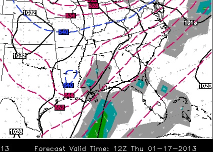
An update now on the Thursday situation. You can read more about that below from the mornings post and especially yesterday's post. You should watch the video as that really explains what could happen. In the model world, it's the NAM vs. the rest of the world. The NAM has an absolutely terrible track record this winter, but at some point, it's going to be right. However, I don't think that's the case here. The only way I'll buy into the NAM scenario is if the GFS or Euro comes around to that solution and that's just not happening. What COULD happen is a comprise between the data and some wintry precip develops, not as heavy, and focused again towards the south. That's just me thinking out loud. Look at the NAM snowfall accumulation below....
 |
| 12Z North American Model (NAM) |
Fast forward to next week. It's looking more likely another big chunk of very cold arctic air will take a nose into the United States. I got a tweet from someone saying highs could be in the single digits. I never say never to Arkansas weather, but that seems highly unlikely. Let's consider this, Little Rock has NOT had a single digit temperature since early February of 1996! That's 17 years ago! We got down to 10 degrees one night in February of 2011 and in December of 2004 if memory serves me correctly. Those were LOW temperatures and NOT high temperatures. Outlying areas away from Little Rock have been in the single digits though, but we go by the official numbers at the Little Rock airport. I have always said there are 4 things needed to get the official number in Little Rock into the single digits: arctic high pressure, clear skies, no winds, and snow cover.
Let's look down the road at the beginning of next week.
 | ||
| This is the new 12Z Euro at midnight next Tuesday. It has the arctic boundary south of us with MUCH colder air coming in on a north-northeasterly wind flow around high pressure located in the Dakota's. That's the 1036mb black line you see. There's a wave of moisture moving through and I'm highly suspicious of that! It's the first and only model run I have seen showing such a scenario, but let's watch it! |
 | |
| The Euro Tuesday morning of the 22nd shows the 32 degree line across southern Arkansas. We have cold air in place, but it's nothing too unusual.What is noticeable here is the -20 to -25 degree air over the Dakota's. BRRRRRRRRRRRRRRRRRRRRRRRRRRR |
 |
| This is the GFS valid next Tuesday morning the 22nd of January. That's COLD! The freezing line is all the way to the Gulf Coast. The temperatures in Arkansas are in the teens and 20s. Again, these are lows and not highs. Bottom line, buckle up, WINTER WILL PACK A PUNCH!!! |
Where do I begin? As I blogged last week, there's sooooooo much on the table for the last half of January it's going to be a challenge to keep up with it all. First of all, let's step back and take notice on how different this winter is compared to the last winter!
The next two weeks will present more challenges, up and down temperatures, and even more chances for precipitation. I'm going straight to the model maps for you this morning. You might want to also check out Sunday's blog post for more very in depth information, especially the video.
 |
| We have the south and southeast corner of the state getting some winter weather today. Here's a hi res model showing yet ANOTHER wave of moisture Tuesday. This could be a bit too far north, but let's watch this for sure. The Pepto Bismol pink (LOL) is ice while the blue is very light snow. Anything falling here would be light, but as always, it can cause problems. |
 | ||
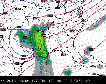
| Now onto the Thursday system I have been blogging about over the past few days. You really must watch the video in the previous blog post to see what I'm watching. The new run of the Euro Thursday morning shows the upper low coming across northern LA and southern AR. HOWEVER, all the precip is shunted off to the east. |
 |
| The new GFS is in good agreement with the above scenario which has me alarmed this could turn out to be nothing for us. But as described in the video in the previous post, I'm not writing it off yet! |
 |
| First of all, the North American Model this winter has been nothing short of HORRIBLE, but it does show the upper low becoming negatively tilted (watch the video below) and it's much further north. This allows a strong surge of moisture on top of cold air resulting in much, much more precipitation across Arkansas Thursday morning. At this time, it's the outlier model and has a bad track record over the past few weeks. For that reason, I think there's well less than a 50/50 chance it will verify. To believe this is "wishcasting" and not "forecasting". With that said, as long as some of the data shows this, it's worth watching and I'm not going to write it off yet. |
 |
| Now onto next week. This is the GFS next Monday evening. There's another surge of cold air coming out of the plains. That's the black closed line in NE S. Dakota. The other black lines surrounding that are isobars indicating air is flowing out of this new high pressure clockwise. A northeasterly wind is developing which would transport another batch of cold air. However, this area of high pressure is 1036 mb and much weaker compared to the operational European model. Look at that below. |
 |
| The Euro next Monday morning shows a 1044mb high coming out of the Dakotas and looks much colder compared to the GFS. So only time will tell how it unfolds. Regardless, after a brief and small late week warm up, ANOTHER batch of cold air will arrive in about 1 week. I'll keep you updated. |


1 comment:
It's official: this winter has made up for last winter. On a side note, it's interesting how JB predicted this to happen 3 WEEKS before it actually happens.
Post a Comment