Wednesday, October 27, 2010

Winter Contest 2010-2011

3:30 PM Monday Update... To see all the Winter Contest entries, click "Winter Contest" on the white bar above.

9 PM Sunday... The contest is closed and I will post all the entries Monday on a special blog page.  I will also comment Monday about the upcoming chilly air heading into Arkansas.  The blog is getting extremely active and it looks like a great week ahead.

I encourage everyone to read the comment section and participate.  You don't have to leave your name... you can be anonymous if you wish.


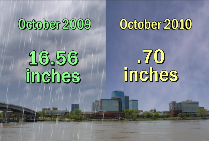
7 AM Friday Update... There's a great question in the comment section.  Does sleet count as snow?  Strangely enough, yes!  The National Weather Service does count them as the same.

Let's kick off the 2nd annual "Arkansas Weather Blog" winter contest.  The contest will go through March 31st, 2011.

This year we will have TWO contests you can enter with GREAT prizes.  We will once again use "Price Is Right" rules.  Whoever guesses the closest without going over wins!

Contest #1
Guess the total COMBINED amount of snow which will fall at the North Little Rock airport, Little Rock airport, Harrison, and Pine Bluff to the nearest tenth of an inch.  The location in Pine Bluff is at the Water Plant and the location in Harrison is @ 3-4 miles south of the airport.  So that there is no confusion... just send one amount.  The total for each location will be determined by the official National Weather Service climate summary.

Prize package:  One year free subscription to weathertap.com, two tickets to the Golden Corral, and a blog t-shirt.

Contest #2
Guess the number of days the low temperature will reach 32 degrees or colder at the North Little Rock airport.  Tie breaker question... guess the amount of snow which will fall at the North Little Rock to the nearest tenth of an inch.

Prize package: 4 tickets to the Golden Corral and an "Arkansas Weather Blog" t-shirt.

SEND ALL ENTRIES TO weather@katv.com.  The deadline will be 9 PM Sunday October 31st.  Good luck!

About the prizes...

This year weathertap.com has agreed to a free 1 year subscription to their service.  If you are not familiar with them, I have a link below.  It's a fantastic site loaded with high resolution radar, satellite, tropical information, and now model data.  They are always finding ways to improve their already awesome products and we're very, very happy they're helping us out.

We're also throwing in "Arkansas Weather Blog" t-shirts.  The shirts were designed by the "WeatherNinja".  Our KATV promotion manager, Rob Thomas, probably the best in the biz, found the resources to get some of these printed up for us!

And of course "WeatherNinja" has generously donated Golden Corral tickets.  We all know the Corral is the place we eat LOTS of good food!


Check out that awesome blog t-shirt!

Rainiest Location in Arkansas Recognized.

From Meteorologist John Robinson of the National Weather Service office...

"Today, we held our ceremony to declare Leola (southwest Grant County) to
commemorate the record rainfall that occurred there last year.

In 2009, Leola set an all-time state rainfall record for Arkansas, when
James Riggan, the National Weather Service cooperative observer,
measured 100.05 inches of rain. The previous record was 98.55 inches at
New Hope (Pike County) in 1957.

In the picture, (left to right):
Pierce Reeder, former mayor of Leola and a former cooperative weather
observer for 35 years in Leola
James Riggan, the current cooperative weather observer in Leola (the
person who measured the 100.05 inches), with the rain gage in his yard
Paul Orr, current mayor of Leola."

Photo courtesy of John Robinson

Monday, October 25, 2010

Severe Weather Photos

Severe Sunday Review

12:30 PM Monday Update... John Robinson with the National Weather Service confirms EF0 damage on Crystal Valley Road just south of Lawson in western Pulaski county.  He tells me that it was a very brief touchdown with no structural damage to homes.  It's just a bunch of tree limbs that are down in that area.  The other damage in Little Rock was thunderstorm wind damage estimated around 60-70 mph.  The wind gust of 63 mph at the LR airport is the highest

__________________________________________________________________

Our 2nd severe weather season kicked off Sunday with sort of a bang.  The tornado warning for Pulaski county was issued right as I was beginning my "First Forecast" on Channel 7 News at 5.  Since it was directly over a very populated area, I decided it would be best to stick with it and continue the coverage.  The rotation was strong as it entered west Little Rock, but began to turn into a damaging thunderstorm wind threat as the storm moved to the east.  It quickly became apparent that a tornado was NOT on the ground since we were not getting any tornado sighting. I talked with Meteorologist John Robinson at the National Weather Service Monday morning.  He's out surveying the damage and thinks that the highest chance of a tornado would have been in far western Pulaski county where a few trees were knocked down along Lawson road.  If that's the case, it would have been on the ground only a brief amount of time and very weak.

In the video, which was taken from downtown LR looking towards the southwest, it appears to be a wall cloud with an appendage.  It's tough to see any rotation with it, but it's possible.

The radar loop in the second video shows the rotation south of I-630 moving east, then it lost its identity as it moved towards downtown and the airport.  Also below, you will see the original issuance of the tornado warning from the National Weather Service.


THE NATIONAL WEATHER SERVICE IN LITTLE ROCK HAS ISSUED A

* TORNADO WARNING FOR...
WEST CENTRAL LONOKE COUNTY IN CENTRAL ARKANSAS...
CENTRAL PULASKI COUNTY IN CENTRAL ARKANSAS...
EAST CENTRAL SALINE COUNTY IN CENTRAL ARKANSAS...

* UNTIL 530 PM CDT

* AT 454 PM CDT...NATIONAL WEATHER SERVICE DOPPLER RADAR INDICATED A
SEVERE THUNDERSTORM CAPABLE OF PRODUCING A TORNADO. THIS SEVERE
STORM WAS LOCATED 4 MILES NORTHWEST OF OTTER CREEK...OR 5 MILES
SOUTHWEST OF WEST LITTLE ROCK. DOPPLER RADAR SHOWED THIS TORNADO
MOVING EAST AT 30 MPH.

* LOCATIONS IN THE PATH OF THIS DANGEROUS STORM INCLUDE...
WEST LITTLE ROCK... SW LITTLE ROCK... SHERWOOD...
N LITTLE ROCK ARPT... NORTH LITTLE ROCK... JACKSONVILLE...
DWNTWN LITTLE ROCK... LITTLE ROCK ARPT... BRYANT...
SYLVAN HILLS... SWEET HOME... SCOTT...
PROTHRO JUNCTION... PARK HILL... OTTER CREEK...
MCALMONT... MABELVALE... LEVY...

PRECAUTIONARY/PREPAREDNESS ACTIONS...

TAKE COVER NOW. MOVE TO AN INTERIOR ROOM ON THE LOWEST FLOOR OF A
STURDY BUILDING. AVOID WINDOWS. IF IN A MOBILE HOME...A VEHICLE OR
OUTDOORS...MOVE TO THE CLOSEST SUBSTANTIAL SHELTER AND PROTECT
YOURSELF FROM FLYING DEBRIS.

Sunday, October 24, 2010

Severe Weather Sunday

Once again, mother nature shows us how fast Arkansas weather can change.  At times it seemed like it would never rain again as much of the state sank into a moderate to severe drought.  Now we're dealing with an active weather pattern with several rain chances.  I want to make it clear, this will not end the drought, but it helps.

As I have discussed on-air, a series of disturbances dropped the weekend weather scale to a 6 with Sunday being the day to watch for severe weather.  The morning disturbance is a very, very good thing, but it may not be enough.  The clouds and rain can help to keep the atmosphere more stable and lessen the degree of severe weather.  The Sunday afternoon/evening disturbance is the one which, if instability developed, could cause problems and this could still happen.

I think we could get enough instability to bring strong to even severe storms posing a wind and hail threat.  Some shear could even bring a tornado into the realm of possibilities.

We also must deal with very windy conditions Sunday and again Monday.  This will not be good to all of those who love looking at the fall foliage.  Some of the trees could get their leaves stripped.

Stay with Channel 7 all throughout the day for the latest info.

SPC severe weather outlook for Sunday

Friday, October 22, 2010

Severe Possible

6 PM Saturday Update... Just wanted to give you an update on our severe threat Sunday.  As of Saturday afternoon, the entire state is under a slight risk for severe weather, but the greatest threat appears to be the southern sections of the state Sunday afternoon and evening.  This is where we may have the greatest amount of instability.  Here's the day 2 outlook from SPC.  I'll have more on the blog Sunday.

SPC day 2 outlook.
We are almost at the one year anniversary of the October 29th tornado outbreak and mother nature is reminding us of her secondary severe weather season.  While I doubt the upcoming weather situation will resemble that day one year ago, we do have to keep our eye to the sky this weekend, especially Sunday.

Our moisture levels are still very, very low and it will take awhile to reach levels which will support severe weather.  Generally, when we see dew point temperatures reach the mid and upper 50s, we really start to pay attention.  This should happen Saturday night into Sunday.  The chance for rain and storms Saturday will mainly stay across Oklahoma and far western Arkansas.  Rain and thunderstorms will increase Saturday night for other areas of the state, but this should not be too bad.  Sunday afternoon, a vigorous disturbance should approach Arkansas.  At this time, dew point temperatures are forecast to rise into the low to mid 60s.  Much of the severe aspect of this will depend on the amount of instability.  If we break out into sunshine, we will have the potential for hail, high winds, and even the risk for isolated tornadoes.  The window for the severe weather should be limited to only a few hours with this situation.  Also, wind speeds this Sunday into Monday will also be elevated.  Even with the recent rainfall, this could enhance the wildfire danger.

Storm Prediction Center places most of Arkansas in a slight risk Sunday

Thursday, October 21, 2010

NOAA Winter Forecast vs. Meteorologist Joe Bastardi

There are a few small differences between the winter forecast released by NOAA Thursday and the one issued by Accuweather.com meteorologist Joe Bastardi.

The winter will be dominated by a significant La Nina pattern which is a cooling of the water in the equatorial Pacific.  The last time we saw this was the winter of 2007-2008.  If we see conditions similar to that year, we can expect an early start to the severe weather season.

Below are graphics from NOAA and I'm re posting the exclusive interview with Joe Bastardi which was done in early August.  Enjoy!

Winter Temperature Forecast from NOAA
Winter Precipitation Forecast from NOAA.


Wednesday, October 20, 2010

Best Blog In Arkansas!

A couple of years ago I asked my wife, Andria, why the weather blog wasn't succeeding.  She quickly responded, you must update it as often as possible and make the content fresh and interesting.  Using her advice, I dedicated as much time as I could and tried to have fun with it. 

Because of her and all of you who read it, the "Arkansas Weather Blog" was recognized Wednesday night by the Society of Professional Journalists as the best blog in Arkansas.

The "WeatherNinja" was a big part of this! He and his wife joined Andria and I at the banquet at UALR.  Check out the pictures.


Todd and the "WeatherNinja"
Coming back to our table after receiving the award
Certificate on the Plaque

Tuesday, October 19, 2010

Weathering Social Media

The way we get our weather  information is so much different than it was just a few years ago and it continues to evolve thanks to mobile devices, twitter, and facebook.

In this edition of the Arkansas Weather Video Blog, KAIT chief meteorologist Ryan Vaughan and I discuss the many aspects of this.

Click Here To Check Out Ryan's Blog

Sunday, October 17, 2010

Dry-Tober 2010 vs. Wet-Tober 2009

At the beginning of October, off the top of my head, I renamed this month "Dry-Tober".  Our weekend sports guy, Dale Nicholson, thought it was "corny" to say the least.  I told him I wanted to communicate how dry I thought this month would turn out to be and it is extremely dry!  Most of the state is in a moderate to severe drought.  There are signs we could get some rain Tuesday and again late this week.  We may be getting into a pattern as we go deeper into fall and eventually winter which gives us more opportunities for wet weather.  Even if that pans out, our precipitation should remain below average.

A viewer sent in a picture of her pond last October and compared it to this October.  The difference is incredible as you can see in the pictures below.  The other graphic shows how we set a rain record in October of 2009.  While this month is desert dry, it's not going to be the driest on record, but it sure feels like it!

What a difference A Year Makes

Comparing Rainfall


Friday, October 15, 2010

Drought Deepens.

The latest drought statement came out Friday from the National Weather Service.  It contained no surprises,  the drought has expanded and worsened across the state and the conditions should not improve much through December.  While I'm very certain we'll get more rain, it should be below the average.

So far this month, Little Rock has received only .7'' of rainfall. North Little Rock has only received .03'' and if the month ended today, it would be the driest on record for our neighbors across the river.  Records in North Little Rock only go back to 1976.

Because of the extremely dry weather, it's fairly easy to get a few dust devils during the heating of the day and this one was sent in from Tuckerman which is just northeast of Newport in Jackson county.

Sent in from Tuckerman, AR Friday Afternoon

Drought Monitor from Friday October 15th


Not Much Relief


Thursday, October 14, 2010

Fighting More Than Just A Fire

All of us in central Arkansas probably noticed the huge amount of smoke coming from North Little Rock today.  The Camp Robinson fire flared up once again reminding us how dangerous conditions are with no soil moisture and low humidity.

I received this email from John Robinson at the National Weather Service office in North Little Rock.  This explains the problems they are having with this particular fire.

"The fire that began Tuesday of last week is the one that flared up again
today.  One reason the Guard is having so much trouble fighting this
fire is that it is on the range, where there are unexploded shells and
other duds.  They can't put people up close to fight the fire because of
exploding shells.  Capt. Heathscott  said if you get near the fire, it's
easy to hear the shells going off."


John Robinson
National Weather Service Meteorologist
North Little Rock, AR

Aerial photo of the Camp Robinson fire from a loyal blogger.

Guy Continues To Shake

The earthquake swarm continues near Guy.  It was very interesting to see the swarm stop for more than a day after the active Monday, but it appears that it's picking up again.

For the past several weeks, most of the quakes were 2.5 or less which isn't felt by most people.  Since last week, we have seen an increase in the magnitude with 4 quakes at 3.0 or above including the big 4.0 last Monday morning.

I'm once again posting the in depth interview with Scott Ausbrooks with the Arkansas Geological Survey.  This was recorded Monday morning and we discuss the possible causes of the swarm.

Tuesday, October 12, 2010

Dry Streak is Over. Drought Continues.

4:30 PM Update... Here is some EXCLUSIVE video of the hail storm in McGehee today from "Jerry".


7:30 PM Tuesday Update... The pictures from McGehee and southeast Arkansas keep rolling into my email box.  Here's two more good ones...

McGehee hail by Amy Kilcrease


Hail covering the ground in McGehee
One area of showers and storms rolled through central Arkansas and it was a very nice thing to see!!  I haven't heard thunder in a very long time!  The stretch of dry days comes to an end at 30 as Adams Field has received .33'' of rainfall.  Records are records for a reason and they are difficult to break!

With this small amount of rain, it won't even put a dent in the drought.  There is some good news down the road however.  I do see a storm system possibly affecting Arkansas around the 20th or 21st.

The upper level low responsible for the rainfall today also helped to promote hail.  Check out this amazing picture below.  It looks like a winter scene as the hail covered the ground.

Another Picture of the small to large hail covering the ground in McGehee, AR

Golf ball size hail in McGehee by Kyle Phillips
Hail covering the playground at McGehee Elem.  photo by LeeAnn

More hail at McGehee Elem by LeeAnn

Hail covering the ground in McGehee, Arkansas Tuesday afternoon (photo by Matt Hughes)


The first rain in Little Rock in 30 days.

Monday, October 11, 2010

This "Guy" Is On Shaky Ground

1:30 PM Monday Update... The USGS officially upgrades morning earthquake in Guy to a 4.0 in magnitude.

Here's the map of the Enola swarm of quakes.  This swarm started in the early 80s and since then there have been more than 40 thousand quakes making it the biggest swarm in the central United States.  There were 3 quakes 4.0 and above in 1982 and one of 4.4 in 2001.  This is a seismically active area even before there was natural gas drilling.  Enola is about 10 miles away from Guy so it's not certain if the Enola swarm is directly related, but it's definitely possible. In the video below, we discuss this with Scott Ausbrook at the Arkansas Geologic Survey.

Read more about the Enola Swarm here from the Arkansas Geological Survey


Over the past week, more than 3 dozen earthquakes have been observed near the town of Guy in northern Faulkner county.  The most powerful one occurred Monday morning and was a 3.8 in magnitude felt by Arkansans from Fayetteville to Jonesboro to Mayflower.

I had the opportunity to speak with Scott Ausbrooks at the Arkansas Geologic Survey.  We discuss the possible connection with the Enola swarm of quakes years ago.  He also says there is the potential for a larger quake as well.  Here's the video.

CLICK HERE FOR THE USGS "EARTHQUAKE LIST"


Sunday, October 10, 2010

Shake, Rattle, & Roll in Northern Arkansas

Since October 4th, the small town of Guy, Arkansas has observed almost three dozen small earthquakes according to the United States Geological Survey (USGS).  Almost all in this swarm have registered a magnitude of 2.5 or less, but something disturbing has occurred since Friday night. Two, rare, 3.0 quakes have rattled the nerves in northern Faulkner county.  The first one was observed at 11:13 PM Friday and the second at 7:48 AM Sunday.

What's causing them?  Everyone has an opinion, but no one knows for sure at this point.  On Friday, Channel 7 reporter, Roger Susanin, traveled to Guy.  CLICK HERE for the story.  This story was filed before the two 3.0 quakes hit the area.

CLICK HERE to follow the earthquakes from the USGS

Saturday, October 09, 2010

Witnessing Weather History

It's just a another in a long string of broken records.  Saturday marks the 116th time this year Little Rock has reached 90 degrees.  Sunday will make it 117.  Weather records in Little Rock date back to 1879 so this is obviously very impressive.

I'm watching two more records which could be broken.  Saturday is day number 28 without any measurable rainfall in Little Rock.  If we reach 32, we will break into the top 10 longest dry periods in weather history.

If we receive about 10 inches or less of rainfall through the end of the year, we will have one of the top 10 driest years in Little Rock weather history.  This is quite remarkable considering last year (2009) was the wettest year in Little Rock.

Friday, October 08, 2010

We Need A Little Of This Rain Now!

LEOLA, Ark. (AP) - The town of Leola in Grant County doesn't
have a lot of people, but it does have a lot of rain.
      The National Weather Service office at North Little Rock said
Friday that a ceremony is planned at Leola, population 515, on Oct.
27 to recognize it as the rainiest-ever spot in Arkansas.
      A news release said the recognition results from the total
rainfall recorded at Leola during 2009 - 100.05 inches. According
to the release, that's the most rain ever recorded at any site in
the state in one year. The previous record was 98.55 inches at New
Hope in Pike County in 1957.
      The Oct. 27 ceremony is to be held at the home of James Riggan,
the Weather Service's official cooperative observer in the
community.

115 of 90

2 PM Friday Update... We did it!  We are now tied for the most 90 degree days in a single year in Little Rock weather history. We will approach 90 through Monday and Tuesday which should put us well into 1st place.

We fell short of the record a few weeks ago and thought it probably wouldn't happen.  Now we have an October heat wave which could put us over the top.  If we hit 90 today, we will tie 1954 and 1980 for most 90 degree days in a single year.

Both computer models have us at 89 for a high Friday so it's going to be close, but I think there's a very good chance for hitting 90.  The airport is basically in a desert right now with a mix of a very dry ground and hot concrete.  The models have underestimated temperatures time and time again so why would today be different?  Dewpoints may come up a few degrees, but I don't think it's enough to have a real impact.

The two major models show a high Saturday of 90 and 91 which would put 2010 over the top.  Stay tuned today and Saturday for updates here and on twitter.

Thursday, October 07, 2010

BIG Award & BIG Thanks To All Of You!

I was told Thursday morning that the Society of Professional Journalists (SPJ) has awarded the Arkansas Weather Blog best blog in the state!

Thanks to everyone who visits and makes this so much fun to do! 

Here's the quote from SPJ about the blog.

"This blog is lively and informative and a neat place to learn more about weather and/or discuss it.  The maps, video charts and other graphics are colorful and useful.  "Arkansas Weather" is a dream come true for weather watchers and fans... and there are a lot of them out there!!"
 

Wednesday, October 06, 2010

Monday, October 04, 2010

Fall Foliage Update

Below is an interview with the Communication Manager of the Arkansas Department of Parks and Tourism, Dean Woerner.  She's our fall foliage expert and tells us when to expect colors to peak and how the weather will affect the color this year.

Remember to send your pictures to photo@katv.com


Sunday, October 03, 2010

October Chill and the Drought

While I'm focusing on the chilly weather for our 5 and 10 o'clock newscasts tonight, it's important to also point out the drought.  Across portions of southern and eastern Arkansas, it's classified as severe.  I don't see any rain for at least the next seven days, but there are a few signs of a system which may generate some precipitation by the middle of the month.

The next two nights should be quite chilly which is perfect to get those leaves changing colors.  The cool air will be replaced by warming conditions by the middle to end of the week with temperatures going well into the 80s.

Possible lows Monday morning

Saturday, October 02, 2010

DRY-tober

I'm officially renaming this month.  As of Saturday, we haven't had significant rainfall in 21 days.  This means we are on pace for another record... consecutive days without measurable rainfall.   Right now, I don't see any over the next 7-10 days which will put us close to the top 10.  Here's the list...

The NEW Arkansas Weather Blog